The accuracy of positioning using global navigation satellite systems (GNSS) is typically limited by physical errors caused by signal propagation through the atmosphere or by factors affecting satellite orbits.
A satellite-based augmentation system (SBAS) can provide devices with additional information to help mitigate these effects and overcome the accuracy limitations of stand-alone GNSS.
As mentioned below, applications in telematic solutions and industrial tracking are just a few areas benefiting from SBAS, which is now considered a mature technology.
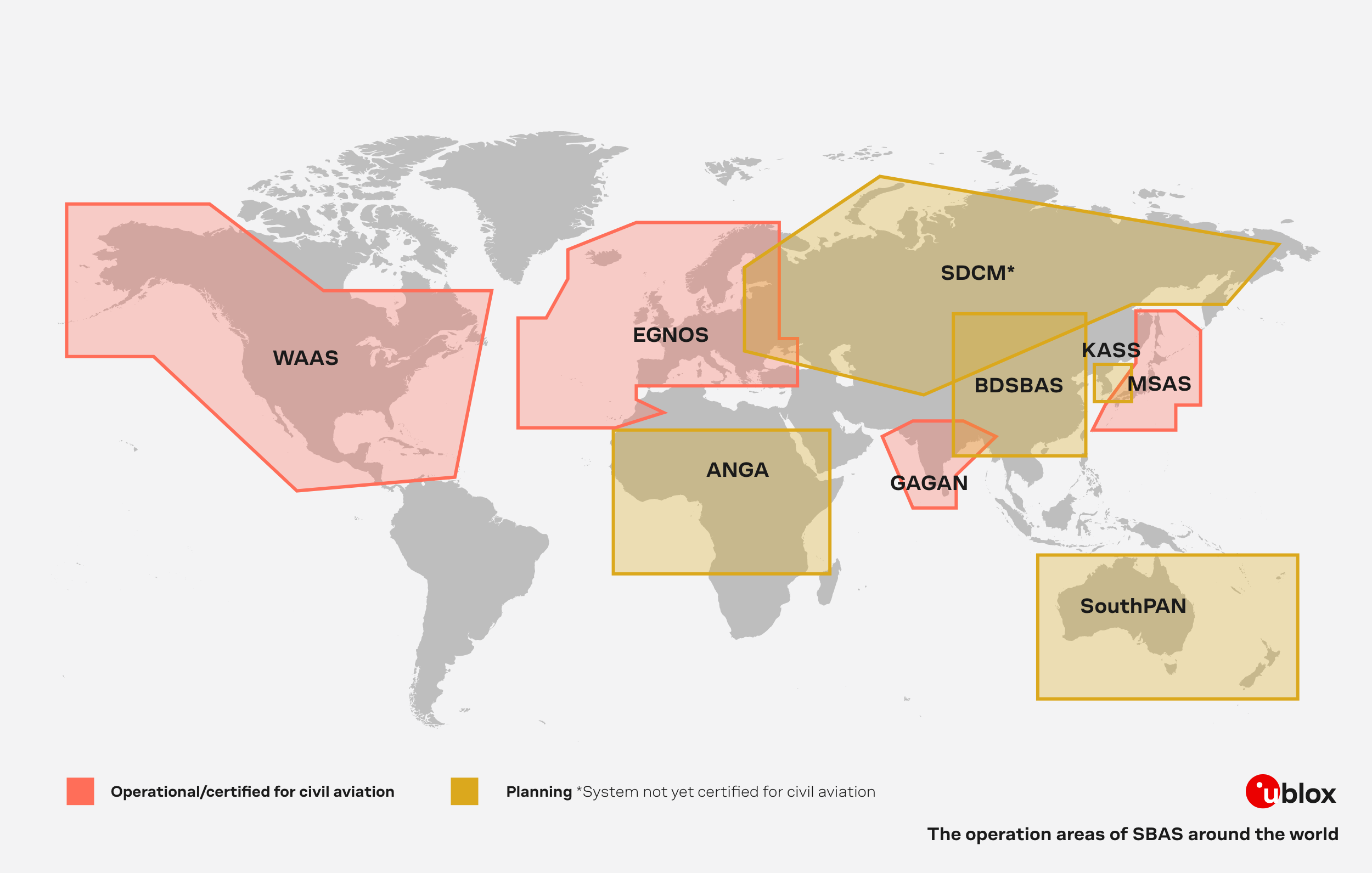
At present, many regions can leverage its coverage, particularly in areas where GNSS accuracy and integrity are critical for applications such as aviation, maritime, and land-based navigation. Yet, SBAS is still not available worldwide.
What is SBAS?
SBAS is a system primarily designed for civil aviation to provide safety-of-life navigation services. In this context, it also provides information on signal integrity. Additionally, and beyond the safety-of-life service tailored to the needs of civil aviation, SBAS offers an open service for broader use, mainly enhancing positioning accuracy.
All currently deployed SBAS systems provide satellite corrections and integrity information to the GPS constellation, also encompassing the safety-of-life service. Moreover, an ionospheric model is transmitted for the designated coverage area, improving positioning accuracy for GPS and other GNSS constellations like Galileo and BeiDou.
There are various SBAS systems available worldwide, covering different regions:
- Wide Area Augmentation System (WAAS): Serves the United States.
- European Geostationary Navigation Overlay Service (EGNOS): Operates in Europe.
- MTSAT satellite augmentation system (MSAS): Used over Japan.
- GPS-aided GEO Augmented Navigation (GAGAN): Operates in India.
How does SBAS work?
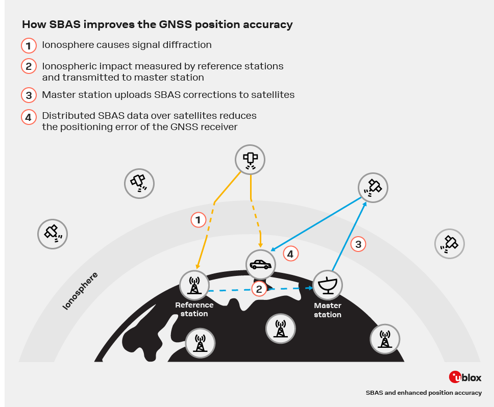
In short, SBAS enhances the accuracy of satellite navigation through four main steps.
- Ground-based reference stations, also known as monitoring stations, track and measure discrepancies in satellite signals and later transmit this data to a master station.
- This master station, often also called control center, processes the data to generate correction factors for errors in the satellite signals. These errors include atmospheric delays, satellite clock errors, and orbital inaccuracies.
- Once the processed data correction signals are generated, they are broadcast to devices via geostationary satellites.
- SBAS-enabled navigation receivers apply these corrections to adjust the standard navigation signals, improving the accuracy of their position calculations using the ionospheric corrections delivered with SBAS. The result is significantly more accurate and reliable navigation information
The benefits
- Improved accuracy. Where available and supported by the GNSS receiver, significant improvements in position accuracy are achieved. By relying on SBAS, positioning errors can often be reduced to within a few meters. Hence, GNSS positioning applications using SBAS provide better positioning accuracy than those that do not.
- Free of charge. Unlike commercial services, SBAS is offered free of charge. With no additional implementation or communication costs associated with other services, SBAS stands out as a reliable tool at no extra cost.
- Availability. As shown in the image above, SBAS is available in large areas of the world, covering countries and even entire regions.
- Operated by a trusted government entity. Key benefits include regulatory compliance, long-term commitment, and security and accountability. SBAS complies with international regulations and standards, ensuring global interoperability and compatibility. Long-term support and infrastructure funding ensure continued operation and updates over time. Finally, operation by a trusted government entity results in stringent security protocols and accountability measures, both of which are essential for reliable critical navigation and positioning services.
Applications
- Telematics solutions or in these areas high precision autonomous machines applications can benefit from SBAS, as downloading SBAS data over satellite takes about 10 minutes, and the downloaded data is only valid for about 15 minutes. Therefore, the GNSS receiver must remain continuously powered on, which is typical in these areas.
- Industrial tracking use cases like livestock monitoring, and rail freight tracking can benefit extensively from SBAS.
Yet, for some asset tracking applications, SBAS may not be compatible. In certain scenarios, the GNSS receiver is switched on briefly to capture initial position information, after which it is switched off to save power. The short period the receiver is on, often less than one minute, is insufficient to receive enough SBAS data. In such cases, an assisted GNSS service like AssistNow online can improve position accuracy after a cold start by downloading data over the internet.
- Dual-band receivers. Ionospheric errors have a more significant effect on L5 than L1 signals. For this reason, SBAS plays a pivotal role in the optimal performance of dual-band (L1/L5) receivers.
- Unmanned Aerial Vehicles (UAVs). SBAS improves the positional accuracy of UAVs, resulting in greater precision and reliability during flight. Increased accuracy is essential for precise landings, automated flight paths, and collision avoidance.
Next steps
SBAS continues to expand its coverage area. In the near future, other significant regions will have access to its correction services. In addition to the established operators, local stakeholders are actively working to establish coverage in other parts of the world at varying paces.
SBAS accuracy will continue to improve over time, with the potential to achieve cm-level precision. This level of accuracy will further benefit high precision positioning applications, such as autonomous vehicles and advanced robotics.
The GNSS product line card provides an overview of u-blox GNSS products that support SBAS. You can find more details on the respective product datasheets.